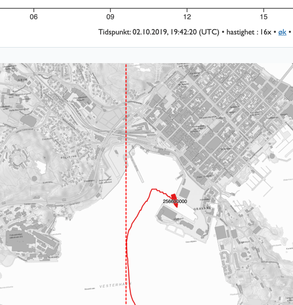
| Ship / Vessel | BALKAN/ JETT (new name) – mmsi: 256600000 / IMO: 9358890 – (container ship) |
| Draft | 8.5 meters |
| Route | Into Berth 9 NOKRS-0002 in Kristiansand |
| Date & Time | 2.10.2019 – Viewing last part of arrival to berth forward to approx 20:00 |
| Tide | +60 cm (Tides are based on the tide table for area – not actual water level at the moment) |
| Purpose of display | Make visible what impact, with smaller margins, has in the inner harbour area the vessel was in (the area has “lost” 60cm depth since the last measurement) |
Display and input during the test

The project does not have access to a complete AIS data basis for the voyage but some data has been extracted via the Norwegian Coastal Administration (NCA). Therefore, there may be inaccuracies in the AIS signals displayed in the demonstrator and the actual route taken. In addition, we lacked information from “message 5” which provides some details about the transponder position on the vessel. We decided the transponder position to be in the centre of the vessel’s bridge.
Pilot Modstein Hansen from the NCA emphasised that exact position data can be difficult to obtain even if you are on board the vessel. If you want to have an exact position, you are dependent on technology and equipment that can provide this en route.
Display of safety margin with “old” depth measurement


With the “old” map bases Tide calculation there is good clearance. The vessel has a draft of 8.5 meters + 7% safety margin and 60cm tide in this view.
Display of safety margin with new updated depth measurement

A new survey for this specific area was done by “Hydrograf” (Norwegian Hydrographic Service) in June 2020. The new survey reveals reduced +60 cm depth at the berth.

By using the same parameters (Draft 8.5m + 7% safety margin) it appears that several obstacles become visible.
Pilot Carl Ellingsen added important information about this particular vessel. It is an older, heavy, flat-bottomed vessel and it is therefore added with port side to the berth. It tapers into the hull on the sides and also by the propeller. This gives room for manoeuvring when the margins are less close to the berth.

John Morten Klingsheim from the NCA points out that there is also an environmental aspect to consider when challenging the margin at ports. Some ports have challenges with different sediment types that swirl up more easily, e.g. knowing if the propeller is getting too close. If you take this element into account when planning, you can limit the vortexing and spreading of contaminated sediment.
Possible consequence of 59cm extra depth at harbour 110
Pilot Master Geir Eikeland referred to PIANC / IMO ‘s work to highlight safe manoeuvring areas and that how the end of the berth, the area for manoeuvring, are important aspects when assessing margins. In this case, it is seen that the end of berth 9 now has clear obstacles compared to what the “old” surveys showed.


Conclusion on display
By taking in the tide level when planning new calls, it is still possible to take in vessels such as the BALKAN at a depth of 8.5m, even if you have “lost” 60cm depth with new measurements.